What are Cold Air Outbreaks?
The CAESAR campaign acronym is for Cold Air Outbreak Experiment in the Sub-Arctic Region. The objective of the campaign is to examine the structure of marine boundary layer clouds during cold air outbreak events. The experiments involves research flights with in situ and remote sensors sampling Arctic air masses from the cold air outbreak origin at the ice edge throughout their transformation downstream. More details about CAESAR can be found here. This begs the question. What are sub-Arctic cold air outbreaks? To answer this question, we first need to examine the concept of an air mass.
What is an air mass?
What is an air mass?
An air mass is a large volume of air that is approximately homogeneous in temperature and moisture. The primary source regions of air masses are the continental Polar (cP), continental Arctic (cA), maritime Tropical (mT), and continental Tropical (cT) regions. Different air masses are separated by frontal boundaries. In the illustration below, the Arctic front separates Arctic from Polar air masses, while the Polar front separates Polar air from warm air masses. The maritime Polar (mP) air masses are secondary air masses that form by the modification of either continental Polar or continental Arctic air as these flow from the continent to the ocean.
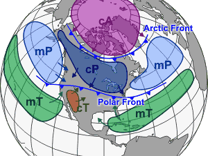
Figure 1. Image Credit: Public Domain via Wikimedia Commons.
Continental Cold Air Outbreak
Continental Cold Air Outbreak
A cold air outbreak is the excursions the Polar or Arctic air mass into other regions. An example of a continental cold air outbreak happened in February 2021 over the North American continent. The Arctic airmass traveled as far south as Texas, resulting in record-low temperatures and in turn causing widespread damage due to winter storms, frozen pipes, and power outages. The animation below illustrates the location of the cA air mass north of the 60°N parallel. On Feb 2, the temperature of the cA air mass was colder than −20°C (−4°F). Starting Feb 4, the cA air mass migrates south. On Feb 15, all of Texas was engulfed by temperatures colder than −10°C (14°F). By Feb 22, the cold air mass had receded and the Arctic front near the 60°N parallel was reestablished.
Figure 2. Illustration of a continental cold air outbreak.
Note that the cold air outbreak cooled the land. However, over time, the land also modified the air mass by gradually warming.
Maritime Cold Air Outbreak
Maritime Cold Air Outbreak
Maritime cold air outbreaks are excursions of the cA air mass over the open unfrozen ocean. Figure 3 shows an example. Note that everywhere north of the red line (the 0°C isotherm), surface air temperatures are below the freezing temperature of water. This implies that there is a strong temperature gradient between the air and the ocean water, which is at ~−2°C. The air temperature becomes rapidly colder toward the ice edge, where surface air temperatures are as cold as −20°C. The temperature difference between the air and water results in heat and moisture transfer from the ocean to the atmosphere. The heat and moisture fluxes have several important consequences on the Earth system. In the atmosphere, intense convective cloud systems produce heavy snowfall. The cold air outbreak may also spawn polar lows, which are mesoscale low pressure systems that affect shipping as well as oil and gas production in the sub-Arctic regions. Figure 4 shows the cloud response to the cold air outbreak. As these broken cloud decks stream southward, they evolve into cellular patterns. These atmospheric cloud systems are poorly represented in weather forecast models.
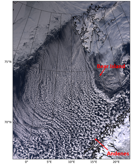
Figure 4. Satellites image over the Fram Strait and Norwegian Sea on March 28, 2020. (Souce: https://arm.gov/news/features/post/69614). The domain corresponds to the region of interest (ROI) in Figure 3. Double click on ROI in the legend of Figure 3 to highlight the domain of the satellite image. The white area in the top left of the image is sea-ice.
The combination of high wind and heat loss from surface water drives Atlantic Meridional Overturning Circulation, which circulates water from north to south and back in a long cycle within the Atlantic Ocean. This circulation is responsible for maintaining ice free conditions around Iceland and on Norways's north coastline, even during winter. The Fram Strait is one of the two main regions in the Atlantic where deep water formation occurs. You may learn more about the Atlantic Meridional Overturning Circulation here.